My time in Torres del Paine had been spectacular so far and I was looking forward to doing some day hikes for the remainder of my second day before heading to hike the western most leg of the W tomorrow. Having hiked over 22 km in the last day my legs were a bit sore, but my lungs were full of the crisp patagonian air and I couldn’t wait to see what more the park had to offer.
This post is the third part of my Patagonia series, head here to read about how to get to Torres del Paine, and click here to know more about hiking to the spectacular Mirador las Torres (the three towers you see glimpses of in the picture below).

I had literally sprinted down from Mirador las Torres, and had reached the car park in great time, covering around 9km in a shade under 3 hours. This left me with plenty of time to do a quick hike around Laguna Azul, one of the best kept secrets of the park and an excellent day hike. To get there, trace your way back to the park entrance, head towards Puerto Natales (out of the park) and you will see a left turn in less than five minutes that heads to Laguna Azul, the road is not paved so drive carefully. It is about 20 km to the lake from the entrance.


At the halfway point you will pass by the Rio Paine waterfall, which makes for an excellent pit stop. I personally found it better than Salto Grande which I visited on my last day in the Park, especially since you can see the three Torres from this fall. Having just stood at the base of the towers barely 6 hours ago it was an eerie moment standing in front of this powerful waterfall with the towers looking so miniscule in the distance!

Once you reach the lake, you will have to make your way to a suitable parking space. The roads aren’t that well marked so it’s best to use the satellite view of google maps to get as close to the lake as you can and then look for a parking spot. Then it’s a simple hike around the deep blue waters of the lake while taking in the views of the entire Torres!

After this refreshing hike, it was time to set up camp at Campground Pehoe. I drove back to the park and near the entrance I saw three guys looking for a ride into the park. The bus from Puerto Natales to the park runs only twice a day, so for hikers who have just finished a hike, it is not the most convenient to get to other places in the park. As luck would have had it, the three guys (who were from the San Francisco bay area) were also headed to camp at Pehoe so they hopped in and we set off for the campground. All roads in the park are unpaved and so don’t trust the times google maps quotes you to get to any place (it usually takes twice the time).

The three guys were doing a semester exchange at the University of Santiago and we chatted about California while driving through the park. It takes about an hour to reach the campsite, and it is a blessing I picked up the 3 guys at the entrance. No one at the campsite spoke a word of english and the guys really helped me out since they were conversant in Spanish. Without them none of the owners would have been able to locate my reservation or tell me which campsite I had booked. See, good deeds get repaid!

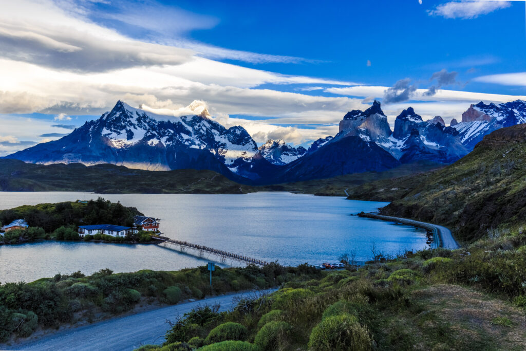
I got busy setting up my tent and then cooked myself some dinner. The campground has some of the most magnificent views inside the park, with the entire mastiff of Cordillera Paine visible in its full glory with the turquoise blue water of Lago Pehoe shimmering beneath. It takes your breath away and will make your jaw drop and stay dropped. I think it is the most scenic place I’ve ever had dinner (a measly ham cheese tomato sandwich with a bar of chocolate for dessert) but the views made it more enjoyable than any Michelin star experience!


Next morning was my day to hike the western most leg of the W and do the glacier hike on Glacier Gray. I was super excited about this as my friend Sandipan had done this hike on his trip last year and I had been blown away by his pictures from the hike. To get to this part of the W you have to make your way to Hotel Lago Gray on the shores of the namesake lake. From here a ferry ride takes you across the Lago Gray to Vertice Refugio Gray which is a stop on the W. The tour starts from there and takes about 6 hours (more details in this post). My plan was to take the first ferry across, do the ice hike and then spend a couple of hours hiking the western leg of the W.

This is where the (mis) adventures started. I got to Hotel Gray right on time, and was informed that due to the fierce Patagonian winds, icebergs had blocked the channel that the ferry has to navigate through to get to the other side. Icebergs, I kid you not, in a lake! Well, I was at nature’s mercy now because the glacier hike tour would start as planned and if the ferry didn’t start in time I would miss it. But you can’t argue with mother nature and I had to prepare for the worst.

About 3 long hours later, the iceberg had finally given way so that the ferry could safely pass through, and we disembarked. Do check the timings here, as the departures vary by season. Also, just a heads up, this is probably the most expensive ferry ride you will ever take, it costs $70 USD one way and $80 RT, but the return trip means you cannot get off the boat at the glacier. So for all practical purposes if you want to do the ice hike, its an additional $140 to and fro. The other cheaper option is to take the Pehoe catamaran but then you have a 8 hr RT hike to the departure point.

Ok, that was my rant for the post, now back to the ferry ride. Cost aside, in terms of sheer jaw dropping beauty, you won’t find many rides that can beat this. We sailed across the lake in very windy, choppy seas, so no one was allowed outside on the deck. Icebergs the size of small houses floated nonchalantly by, and we got a glimpse of the god-forsaken berg which had caused the delay! I could only seethe in silent anger hahahaha! Apart from the stunning scenery, they also treat everyone to a pisco sour (the chilean one, its a sore point of dispute between Chileans and Peruvians apparently) topped off with ice from the Gray glacier!! How is that for coolness (pun intended)!


Ferry ride over, me and the other folks who were scheduled for the ice hike finally disembarked and made our way to the Bigfoot camp (the hike organizers). Our worst fears had come true, the ice hike group had left an hour back, and because of the adverse weather there wasn’t a way we could kayak across the lake and join them. The crew at Bigfoot were super amazing though, knowing most of us had travelled halfway across the world to experience this, they put together an ad-hoc zodiac tour that would take us to close to the glacier and if weather permitted we would attempt a landing and walk around for a bit. This was uplifting news indeed!

The zodiac would be ready to leave in a couple of hours, so I used that time to do my hike of this leg of the W. Truthfully speaking, I hiked north from Refugio Gray, and that constitutes the Q hike, which is basically completing the loop of the W. But there are two spectacular wooden bridges that cross over deep ravines with stunning views of Glacier Gray to keep you company. Totally worth it and the scenery is better than what you see if you hike south to Paine Grande.


Short hike done, it was time for the much awaited Zodiac ride. We strapped in, out on protective gear and set off. Words can’t describe how large the glacier walls look when you are less than a km away. And the shade of turquoise, translucent blue.. Oohhh! Has to be seen to be believed. That certainly made up a little for my disappointment of not being able to do the ice hike.

Couple of hours later, we were back to camp, and then it was a long wait for the ferry ride back to Hotel Lago Gray. Sadly the iceberg fiasco had delayed the entire schedule for the day so we had to wait for a couple more hours to get the ride back, things could have been far worse though. Couple of days back the weather was so bad that the ferry couldn’t come back to pick up passengers and everyone had to huddle on the floor and stay overnight in the refugio. My advice, have a couple of days’ cushion to account for such weather related events which are out of your control, but happen with eerie regularity in Patagonia!
The ride back was uneventful, we got treated to another Pisco sour, (still one of my all time favorite cocktails). I had an interesting chat with a French doctor from Toulouse who had just completed the 5 day full W hike. He loved India and had visited 6 times, his favorite city being Banaras. Was great chatting to him about the similarities of the culture of the two countries. One of the great charms of solo travel is the conversations you strike with fellow travellers and it gives you an interesting perspective of life.


After that, it was back to camp, to a dinner of ham, cheese and tomato on wheat bread! Next morning, Madhu was flying in from Santiago so I did a couple of small hikes in the morning (would highly recommend Mirador Condor for the best views of Pehoe) before driving back to Punta Arenas airport to pick up the wife. The plan was to then drive back to Puerto Natales for the night and spend day 5 doing a drive through of the park and showing her the main sights. She is not much into hiking so I did the hiking parts alone and then she joined me for the rest of my South American sabbatical.

Next stop was the cities of Valparaiso and Santiago for a quick break, and also to get our Bolivian visas, and then it was onto Atacama for the high altitude part of our trip. We were super pumped.
I hope you like my three part series about Patagonia. Please leave a comment below if you’ve been or its on your wish list! Patagonia is pristine nature, let’s all vow to keep it like that for future generations. I really like this quote, “When in nature, take back memories, but leave nothing behind but footprints”.

You had better weather than us by the looks of it. I love the picture of the Cuernos with the alpenglow.
Thanks so much! I agree, we were blessed with excellent weather…